
 In suburban areas where few people currently cycle, the goal of increasing cycling can seem like a daunting one. Starting with a targeted approach in select neighbourhoods and expanding outwards is likely to be more effective than a broad, city-wide campaign. Mapping can be used to reveal differences between neighbourhoods and identify locations with a built environment and transportation patterns that are more conducive to cycling. In a study we conducted (Savan & Young, publication pending) of Toronto urban and suburban neighbourhoods, factors such as the percentage of short trips, the average number of daily trips per person, and the average number of vehicles per adult in a household were associated with changes in cycling rates. By mapping these factors in areas where cycling is low, we can identify neighbourhoods where conditions are more supportive for cycling and cycling programs and infrastructure may see greater success.
ACTIONS
- Use available transportation and built environment data to identify neighbourhoods with low rates of cycling, but good potential. Partner with local organizations to offer cycling programs in these neighbourhoods to start, and then look for opportunities to expand outwards.
EXAMPLES
- Ryerson University and The Centre for Active Transportation mapped cycling potential in the Greater Toronto and Hamilton Area for Metrolinx, and found that one third of all trips (4.3 million trips per day) are 5 km long or less and could be cycled. This pattern held true across the region, including more suburban municipalities. In particular, 22% of trips to suburban regional rail stations showed potential for being converted to cycling.
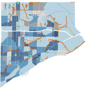
- Scarborough Cycles, a project in a suburban district east of Toronto’s downtown, mapped built environment and transportation factors to identify neighbourhoods conducive to cycling. Two suburban community bike hubs were opened in promising locations to incubate cycling through concentrated cycling programming.