
Like many Ontarians, at TCAT we are concerned about the potential negative impact of the recent provincial announcement regarding cuts to public health and consolidation of health units (from 35 to 10). The critical functions that public health units serve include disease prevention, water quality testing, food safety regulation, infection disease control, and more. To add to this long list, public health units also collaborate with municipalities to build safe and healthy streets for all.
Last month, TCAT concluded a research project that investigated how Ontario’s 35 public health units work most effectively with their communities to achieve community design that improves population health. The project was commissioned to respond to the 2018 Ontario Public Health Standards regarding Healthy Environments and Climate Change which direct health units to collaborate with municipalities to promote healthy built and natural environments.
With the assistance of two public health specialists (Windemere Jarvis and Thrmiga Sathiyamoorthy) and planner Yvonne Verlinden, the TCAT team conducted a literature review, designed and implemented an online survey to all Ontario public health units, conducted key informant interviews with provincial professional planners, and led focus groups with seven Ontario health units who had successful examples of interventions to inform the municipal planning process in promoting healthy built environments. The researchers documented promising practices and gathered advice to assist other health units.
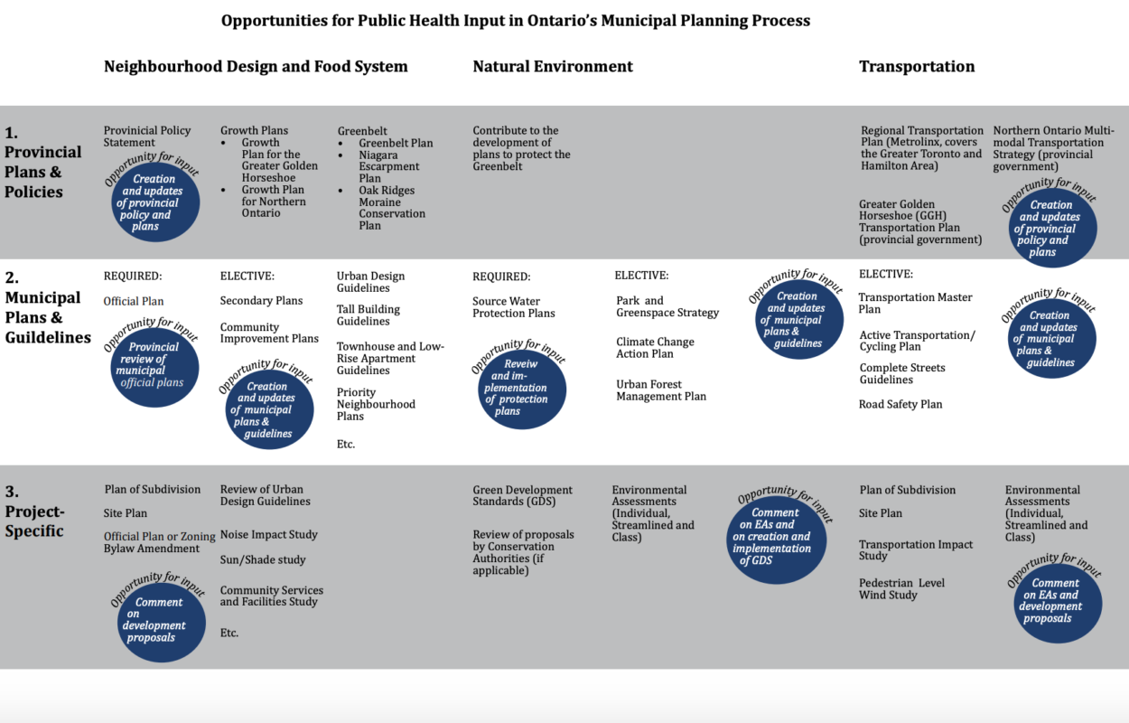
One interesting aspect of the research was the mapping out of the municipal planning process in Ontario to identify opportunities for public health input. In the review of the literature there were four spheres identified where the built environment impacts health: Neighbourhood Design, Food System, Natural Environment, and Transportation. The types of impacts and interventions described within each sphere were reviewed and corresponding planning tools to influence outcomes were identified. Significant overlap was found between planning tools to address Neighbourhood Design and Food System so these were combined in the map. Three scales of land use planning were identified: Provincial Plans & Policies, Municipal Plans & Guidelines, and Project-Specific. The map above shows the applicable planning tools across these three scales and four spheres and identifies the opportunities for public health input.
Dr. Charles Gardner, Medical Officer of Health for Simcoe Muskoka District Health Unit, will be presenting the project findings on May 1, 2019 at the Canadian Public Health Association conference in Ottawa.
The next planned phase of work, pending funding, is to be a public-facing resource to support Ontario public health units as they engage with communities in planning, implementing, monitoring and measuring local efforts to achieve health-protective, health-promoting, and health-equitable community design. It’s not clear yet what impact the recent announcement may have on this work moving forward.